Region di Singapura
Halaman ini sedang dipersiapkan dan dikembangkan sehingga mungkin terjadi perubahan besar. Anda dapat membantu dalam penyuntingan halaman ini. Halaman ini terakhir disunting oleh 미솔파 (Kontrib • Log) 2144 hari 125 menit lalu. Jika Anda melihat halaman ini tidak disunting dalam beberapa hari, mohon hapus templat ini. |
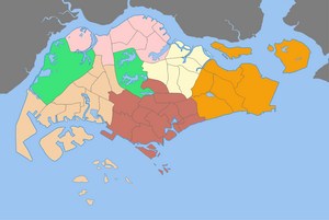
The Regions of Singapore are urban planning subdivisions demarcated by the Urban Redevelopment Authority of Singapore to aid in its planning efforts. Over time, however, other governmental organisations have also adopted the five regions in their administrative work, as for example the Department of Statistics in the census of 2000. The regions are further subdivided into 55 planning areas, which include two water-catchment areas. The largest region in terms of area is the West Region with 2.013 km2 (777 sq mi), while the Central Region is the most populous with 939,890 inhabitants in the area in 2015.
| Daerah Singapura | |
|---|---|
| Juga dikenal sebagai: 新加坡的地区 (Mandarin) Kawasan Singapura (Malay) சிங்கப்பூர் பகுதிகள் (Tamil) | |
 | |
| Kategori | Unitary State |
| Letak | Republic of Singapore |
| Dibentuk oleh | Urban Redevelopment Authority |
| Dibentuk | September 1991 (proposed)[1] 22 January 1999 (gazetted)[2] |
| Jumlah wilayah | 5 (hingga 2018) |
| Penduduk | 557,830 (North Region) – 925,930 (Central Region)[3] |
| Luas | 931 kilometer persegi (359 sq mi) (East Region) – 2.013 kilometer persegi (777 sq mi) (West Region)[3] |
| Pemerintahan | CDC districts National Government |
| Pembagian administratif | Planning Areas |
While utilised by some governmental organizations, these regions are not administrative subdivisions. For administrative purposes, Singapore is divided into five districts and further divided into divisions governed by councils and headed by mayors. These subdivisions are incompatible with the region subdivisions. The regions are fixed over time while the districts fluctuate with electoral redistricting.
List of regions
| Region[3] | Regional Centre | Largest PA by area | Largest PA by population | Area (km²) |
Population | Population density (/km²) |
Planning Areas |
|---|---|---|---|---|---|---|---|
| Central Region | Central Area (de facto) | Queenstown | Bukit Merah | 132.7 | 925,930 | 6,978 | 22 |
| East Region | Tampines | Changi | Bedok | 93.1 | 687,500 | 7,385 | 6 |
| North Region | Woodlands | Central Water Catchment | Woodlands | 134.5 | 557,830 | 4,147 | 8 |
| North-East Region | Seletar (proposed) | North-Eastern Islands | Sengkang | 103.9 | 908,490 | 8,744 | 7 |
| West Region | Jurong East | Western Water Catchment | Jurong West | 201.3 | 914,570 | 4,543 | 12 |
| Total | 665.5 | 3,994,320 | 6,002 | 55 |