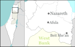
Sulam
Sulam (bahasa Arab: سولم; Ibrani: סוּלַם)[2] adalah sebuah desa Arab di timur laut Israel. Dikenal pada zaman kuno sebagai Sunama dan Sunem, desa tersebut pertama kali disebutkan dalam Surat-surat Amarna pada abad ke-14 SM. Ekskavasi arkeologi di desa tersebut menunjukkan bahwa tempat tersebut telah didudki dari Zaman Perunggu sampai zaman modern. Terletak dekat Afula, desa tersebut berada di bawah yurisdiksi Dewan Regional Bustan al-Marj. Pada 2022, desa tersebut memiliki populasi 2,710.[1]
Sulam
סוּלַם سولم | |
|---|---|
 Sulam, dilihat dari Nabi Dahi | |
| Koordinat: 32°36′20″N 35°20′04″E / 32.60556°N 35.33444°E | |
| Grid position | 181/223 PAL |
| Distrik | Utara |
| Dewan | Bustan al-Marj |
| Populasi (2022)[1] | 2.710 |
Referensi
- ^ a b "Regional Statistics". Israel Central Bureau of Statistics. Diakses tanggal 21 March 2024.
- ^ Palmer, 1881, p.167
Daftar pustaka
- Alexandre, Yardenna (2008-03-26). "Sulam Final Report" (120). Hadashot Arkheologiyot – Excavations and Surveys in Israel.
- Barron, J.B., ed. (1923). Palestine: Report and General Abstracts of the Census of 1922. Government of Palestine.
- Covello-Paran, Karen (2006-09-10). "Sulam" (118). Hadashot Arkheologiyot – Excavations and Surveys in Israel.
- Covello-Paran, Karen (2010-02-07). "Sulam" (122). Hadashot Arkheologiyot – Excavations and Surveys in Israel.
- Conder, C.R.; Kitchener, H.H. (1882). The Survey of Western Palestine: Memoirs of the Topography, Orography, Hydrography, and Archaeology. 2. London: Committee of the Palestine Exploration Fund.
- Dalali-Amos, Edna (2009-02-14). "Sulam Final Report" (121). Hadashot Arkheologiyot – Excavations and Surveys in Israel.
- Dalali-Amos, Edna (2009-12-02). "Sulam Final Report" (121). Hadashot Arkheologiyot – Excavations and Surveys in Israel.
- Dalali-Amos, Edna (2009-12-05). "Sulam Final Report" (121). Hadashot Arkheologiyot – Excavations and Surveys in Israel.
- Government of Palestine, Department of Statistics (1945). Village Statistics, April, 1945.
- Goren, Yuval et al., (2004). Yuval Goren, I. Finkelstein, Michal Artzy, ed. Inscribed in clay: provenance study of the Amarna tablets and other ancient Near Eastern texts. Emery and Claire Yass Publications in Archaeology (Original from the University of Michigan). ISBN 9789652660206.
- Guérin, V. (1880). Description Géographique Historique et Archéologique de la Palestine (dalam bahasa French). 3: Galilee, pt. 1. Paris: L'Imprimerie Nationale. p.112 - p. 114
- Hadawi, S. (1970). Village Statistics of 1945: A Classification of Land and Area ownership in Palestine. Palestine Liberation Organization Research Center.
- Hanna, Butrus (2008-01-08). "Sulam" (120). Hadashot Arkheologiyot – Excavations and Surveys in Israel.
- Hütteroth, Wolf-Dieter; Abdulfattah, Kamal (1977). Historical Geography of Palestine, Transjordan and Southern Syria in the Late 16th Century. Erlanger Geographische Arbeiten, Sonderband 5. Erlangen, Germany: Vorstand der Fränkischen Geographischen Gesellschaft. ISBN 3-920405-41-2.
- Karmon, Y. (1960). "An Analysis of Jacotin's Map of Palestine" (PDF). Israel Exploration Journal. 10 (3,4): 155–173; 244–253.
- Mills, E., ed. (1932). Census of Palestine 1931. Population of Villages, Towns and Administrative Areas. Jerusalem: Government of Palestine.
- Palmer, E.H. (1881). The Survey of Western Palestine: Arabic and English Name Lists Collected During the Survey by Lieutenants Conder and Kitchener, R. E. Transliterated and Explained by E.H. Palmer. Committee of the Palestine Exploration Fund.
- Robinson, E.; Smith, E. (1841). Biblical Researches in Palestine, Mount Sinai and Arabia Petraea: A Journal of Travels in the year 1838. 3. Boston: Crocker & Brewster.
- Tsafrir, Y.; Leah Di Segni; Judith Green (1994). (TIR): Tabula Imperii Romani: Judaea, Palaestina. Jerusalem: Israel Academy of Sciences and Humanities. ISBN 965-208-107-8.
- Wilson, C.W., ed. (c. 1881). Picturesque Palestine, Sinai and Egypt. 2. New York: D. Appleton.
Pranala luar
- Welcome To Sulam (Shunem)
- Survey of Western Palestine, Map 9: IAA, Wikimedia commons
