Berkas:LocationSouthAfrica-1990.png
Tak tersedia resolusi yang lebih tinggi.
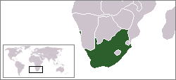
LocationSouthAfrica-1990.png (250 × 115 piksel, ukuran berkas: 5 KB, tipe MIME: image/png)

|
File:South Africa in its region (1990).svg merupakan versi vektor dari berkas ini. Berkas itu harus digunakan menggantikan gambar raster ini jika kualitasnya tidak rendah.
File:LocationSouthAfrica-1990.png → File:South Africa in its region (1990).svg
Untuk informasi lanjutan, lihat Bantuan:SVG. |
.svg) |
Ringkasan
A locator map of South Africa showing en:Walvis Bay. This locator map is intended for South African articles taking place before the transfer of Walvis Bay to Namibia in 1994. The orginal map is by Vardion. Since that map is PD, this one is well.
Lisensi
| Karya ini dilepaskan ke domain umum oleh pemiliknya, Hoshie. Lisensi ini berlaku di seluruh dunia. Di sejumlah negara, tindakan ini tidak memungkinkan secara sah; bila seperti itu: |
Riwayat berkas
Klik pada tanggal/waktu untuk melihat berkas ini pada saat tersebut.
| Tanggal/Waktu | Miniatur | Dimensi | Pengguna | Komentar | |
|---|---|---|---|---|---|
| terkini | 17 Desember 2009 07.26 | | 250 × 115 (5 KB) | Hoshie | Reverted to version as of 03:34, 16 August 2006 rv, Nambia itself wasn't a part of S. Africa |
| 2 Desember 2008 18.37 |  | 250 × 115 (5 KB) | ChrisDHDR | South Africa included Namibia at the time | |
| 16 Agustus 2006 03.34 |  | 250 × 115 (5 KB) | Hoshie | == Summary == A locator map of South Africa showing en:Walvis Bay. This locator map is intended for South African articles taking place before the transfer of Walvis Bay to Nambia in 1994. The orginal map is by [[Us |
Penggunaan berkas
Tidak ada halaman yang menggunakan berkas ini.