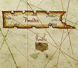
Antillia
Antillia (atau Antilia) adalah sebuah pulau fantom, pada zaman penjelajahan abad ke-15, yang berada di Samudera Atlantik, yang berada jauh di sebelah barat Portugal dan Spanyol. Pulau tersebut juga dinamai Pulau Tujuh Kota (Ilha das Sete Cidades dalam bahasa Portugis, Isla de las Siete Ciudades dalam bahasa Spanyol).
| Antillia | |
|---|---|
 Peta Albino de Canepa, 1489. Pulau fantom Antillia, dengan Tujuh Kota-nya, di bagian kanan; pulau kecil Roilloberada di bagian kirinya. | |
| Carter portolan | |
| Tipe | Pulau fantom |
Pulau tersebut bermula dari sebuah legenda Iberia lama, yang dibuat pada masa penaklukan Muslim di Hispania pada sekitar tahun 714. Dalam rangka menghindari para penakluk Muslim, tujuh uskup Visigothik Kristen berlayar menuju Samudera Atlantik, kemudian mendarat ke sebuah pulau (Antilha) dimana mereka mendirikan tujuh pemukiman.
Referensi
Sumber
- Babcock, W.H. (1920) "Antillia and the Antilles", Geographical Review, vol. 9 (2), p. 109-24.
- Babcock, W.H. (1922) Legendary islands of the Atlantic: a study in medieval geography New York: American Geographical Society. online
- Barreto, M. (1988) O português Cristóvão Colombo, 1992 trans. as The Portuguese Columbus: secret agent of King John II. New York: Macmillan.
- Beazley, C.R. (1897–1906) The Dawn of Modern Geography. London. vol. 1 (-900), vol.2 (900-1260) vol. 3 (1260–1420)
- Beazley, C. (1899) Raymond "Introduction" in C.R. Beazley and E. Prestage, 1898–99, The Chronicle of the Discovery and Conquest of Guinea, London: Halyut. v.2
- Buache, Jean-Nicholas (1806) "Recherches sur l'île Antillia et sur l'époque de la découverte de l'AmériqueMémoires de l'Institut des Sciences, Lettres et Arts, Vol. 6, Paris: Baudoin, p.1-29
- Columbus, Ferdinand (c. 1539) Historia del Almirante Don Cristobal Colon, en la cual se da particular y verdadera relacion de su vida y de sus hechos, y del descubrimiento de las Indias Occidentales, llamadas Nuevo-Mundo (1892 Madrid edition, 5 volumes)
- Cortesão, Armando (1953) "The North Atlantic Nautical Chart of 1424" Imago Mundi, Vol. 10. JSTOR
- Cortesão, Armando (1954) The Nautical Chart of 1424 and the Early Discovery and Cartographical Representation of America. Coimbra and Minneapolis. (Portuguese trans. "A Carta Nautica de 1424", published in 1975, Esparsos, Coimbra. vol. 3)
- Cortesão, Armando (1970) "Pizzigano's Chart of 1424", Revista da Universidade de Coimbra, Vol. 24 (offprint),
- Crone, G. R. (1938) "The Origin of the Name Antillia", The Geographical Journal, Vol. 91, No. 3 (Mar.), pp. 260–262
- Crone, G.R. (1947) "The Pizigano Chart and the 'Pillars of Hercules'", The Geographical Journal, Apr-Jun, Vol.100, p. 278-9.
- D'Avezac, M.A.P. Marquis (1845) Les îles fantastiques de l'océan occidental au moyen âge: fragment inédit d'une histoire des îles de l'Afrique. Paris: Fain & Thunot. online
- Dickson, Donald R. "The Tessera of Antilia: Utopian Brotherhoods & Secret Societies in the Early Seventeenth Century." Leiden, New York, and Köln: E. J. Brill, 1998
- de Faria e Sousa, Manuel (1628) Epítome de las historias portuguesas: dividido en quatro partes 1677 edition, Brussels: Foppens. online
- Formaleoni, Vicenzio (1783) Saggio sulla Nautica antica de' Veneziani, con una illustrazione d'alcune carte idrografiche antiché della Biblioteca di S. Marco, che dimonstrano l'isole Antille prima della scoperta di Cristoforo Colombo. Venice. online
- Gaffarel, Paul (1882) "L'île des Sept Cités et l'île Antilia", Congresso Internacional de Americanistas, Actas de la Cuara Reunión, Madrid, Madrid: Fortanet, vol. 1, p.198
- Galvão, António (1563) Tratado que compôs o nobre & notauel capitão Antonio Galuão, dos diuersos & desuayrados caminhos, por onde nos tempos passados a pimenta & especearia veyo da India às nossas partes, & assi de todos os descobrimentos antigos & modernos, que são feitos até a era de 1550, Lisbon (trans. R. Hakluyt, 1601, as The Discoveries of the World from Their First Original Unto the Year of Our Lord 1555. 1862 edition, London: Hakluyt online)
- Hassel, George (1822) "America - Einleitung" in Caspari, et al. editors, Vollständiges Handbuch der neuesten Erdbeschreibung, Weimar: Geographischen Instituts. vol. 1 - p.6
- Hennig, R. (1945) "Eine altes Rätsel der Pizigano-Karte gelöst" in Mitteilungen der geographischen Gesellschaft Wien, vol. 88, p. 53-56.
- * Higginson, Thomas Wentworth (1899) Tales of the Enchanted Islands of the Atlantic. New York: Macmillan.online
- von Humboldt, Alexander (1837) Examen critique de l'histoire de la géographie du nouveau continent et des progrès de l'astronomie nautique aux quinzième et seizième siècles, Paris: Gide, vol. II.
- Kretschmer, Konrad (1892) Die Entdeckung Amerika's in ihrer Bedeutung für die Geschichte des Weltbildes. Berlin: Kühl. online
- de Medina, Pedro (1548) Libro de las grandezas y cosas memorables de España. Seville. (1595 edition, Alcala de Henares: Iuan Gracian, online
- Morison, S.E. (1940) Portuguese voyages to America in the fifteenth century Cambridge, Mass: Harvard University Press.
- Morison, S.E. (1955) "Review of Cortesão's 'Nautical Chart of 1424'", Speculum, Vol. 30 (3), p. 467-70.
- Nansen, Fridtjof (1911) In Northern Mists; Arctic exploration in early times. New York: F.A. Stokes. vol. 1, vol. 2
- Nordenskiöld, Adolf Erik (1897) Periplus: An Essay on the Early History of Charts and Sailing Directions, tr. Frances A. Bather, Stockholm: Norstedt.
- O'Curry, Eugene (1861) Lectures on the Manuscript Materials of Ancient Irish History, delivered at the Catholic University of Ireland, during the sessions of 1855 and 1856. Dublin: Duffy. p.289).
- La Ronciere, Charles de (1924) La carte de Cristophe Colomb, Paris: Champion
- Spence, Lewis (1925) The Problem of Atlantis. London: Rider.
- Vignaud, H. (1902) Toscanelli and Columbus: The letter and chart of Toscanelli on the route to the Indies by way of the west, sent in 1474 to the Portuguese, Ferman Martins, and later on to Christopher Columbus; a critical study on the authenticity and value of these documents and the sources of the cosmographical ideas of Columbus, followed by the various texts of the letter. London: Sands. online
- Vignaud, H. (June, 1902) "Did Columbus Discover America?", Everybody's Magazine, June, 1902, Vol. 6, No.6, p.549.
- Artikel ini menyertakan teks dari suatu terbitan yang sekarang berada pada ranah publik: Chisholm, Hugh, ed. (1911). "Antilia". Encyclopædia Britannica (edisi ke-11). Cambridge University Press.