Perbatasan Kashmir–Tiongkok

salah satu perbatasan negara
Revisi sejak 25 November 2017 06.07 oleh Pierrewee (bicara | kontrib) (←Membuat halaman berisi '{{Distinguish|Garis Kontrol}} Berkas:Kashmir map big.jpg|thumb|330px|The western portion of the Line of Actual Control, which lies between Chinese-controlled and Ind...')
(beda) ← Revisi sebelumnya | Revisi terkini (beda) | Revisi selanjutnya → (beda)

Garis Kontrol Aktual (LAC) adalah sebuah garis demarkasi yang memisahkan wilayah yang dikuasai India dengan wilayah yang dikuasai oleh Tiongkok di bekas negara kepangeranan Jammu dan Kashmir.[1]
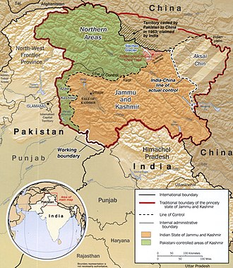
The western portion of the Line of Actual Control, which lies between Chinese-controlled and Indian-controlled territory in the Himalayan region. The line was the focus of a brief war in 1962, when Indian and Chinese forces struggled to control land where, "not even a blade of grass grows," as Indian Prime Minister Jawaharlal Nehru put it.
The map shows the Indian and Chinese claims of the border in the western (Aksai Chin) region, the Macartney–MacDonald line, the Foreign Office Line, as well as the progress of Chinese forces as they reached the Line of Actual Control during the Sino-Indian War.

Lihat juga

Referensi

Kutipan

Sumber