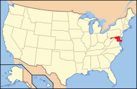
County Baltimore, Maryland
39°24′N 76°36′W / 39.400°N 76.600°W
| Baltimore County, Maryland | |||
|---|---|---|---|
 Baltimore County Courthouse | |||
| |||
 Lokasi di negara bagian Maryland | |||
 Lokasi negara bagian Maryland di Amerika Serikat | |||
| Didirikan | 1659 | ||
| Asal nama | Cecil Calvert, Baron Baltimore | ||
| Seat | Towson | ||
| Wilayah | |||
| • Keseluruhan | 68.203 sq mi (176.645 km2) | ||
| • Daratan | 59.859 sq mi (155.034 km2) | ||
| • Perairan | 8.344 sq mi (21.611 km2), 12.23% | ||
| Populasi | |||
| • (2010) | 805.029 | ||
| • Kepadatan | 1.345/sq mi (519,3/km²) | ||
| Distrik kongress | 1st, 2nd, 3rd, 7th | ||
| Zona waktu | Timur: UTC-5 (EST) / -4 (EDT) | ||
| Situs web | www | ||
Baltimore County adalah county yang terletak di bagian utara Negara Bagian Maryland. Berdasarkan Sensus 2010, jumlah penduduk di county ini mencapai 805,029 jiwa.[1] County seat dari county ini berada di Towson.[2] Nama County ini diambil dari Kebaronan dari Proprietari Koloni Maryland, Cæcilius Calvert, Baron Baltimore, dan Kota "Baltimore" di County Longford, Irlandia.
Referensi
- ^ "State & County QuickFacts". United States Census Bureau. Diakses tanggal August 20, 2013.
- ^ "Find a County". National Association of Counties. Diakses tanggal 2011-06-07.

