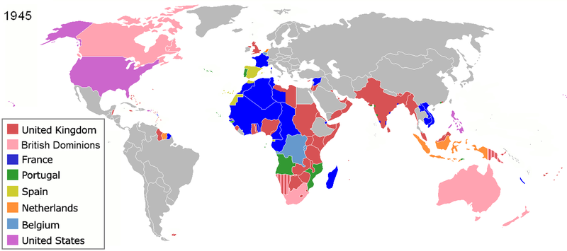
Berkas:Colonization 1945.png

Ukuran pratayang ini: 800 × 355 piksel. Resolusi lainnya: 320 × 142 piksel | 640 × 284 piksel | 1.438 × 638 piksel.
Ukuran asli (1.438 × 638 piksel, ukuran berkas: 85 KB, tipe MIME: image/png)
Riwayat berkas
Klik pada tanggal/waktu untuk melihat berkas ini pada saat tersebut.
| Tanggal/Waktu | Miniatur | Dimensi | Pengguna | Komentar | |
|---|---|---|---|---|---|
| terkini | 28 Juni 2019 17.20 |  | 1.438 × 638 (85 KB) | Andres.tv | Recovering the large size of the image and improving the color for France. |
| 20 Juli 2018 22.08 |  | 800 × 355 (1,09 MB) | SuperSucker | UK | |
| 10 Agustus 2016 07.42 |  | 1.438 × 638 (92 KB) | Sebastiano Mugnaio | Reverted to version as of 14:08, 26 August 2012 (UTC) - sorry, meant this one... | |
| 10 Agustus 2016 07.41 |  | 1.438 × 638 (92 KB) | Sebastiano Mugnaio | Reverted to version as of 14:08, 26 August 2012 (UTC) - Japan and Germany as colonies is rather awkward. | |
| 14 Agustus 2015 10.58 |  | 1.438 × 638 (89 KB) | Palaeozoic99 | Fixed Newfoundland; it was a British Dominion from 1907-1949. | |
| 11 Agustus 2015 18.56 |  | 1.438 × 638 (103 KB) | Alghenius | Corrected | |
| 26 Agustus 2012 14.08 |  | 1.438 × 638 (92 KB) | Hamodi1234 | Fixed Brazil | |
| 26 Agustus 2012 14.05 |  | 1.438 × 638 (92 KB) | Hamodi1234 | Fixed Brazil and Syria | |
| 24 Juli 2012 14.04 |  | 1.438 × 638 (81 KB) | Soerfm | Legend | |
| 9 Juni 2012 09.14 |  | 1.425 × 625 (46 KB) | Ozzorro~commonswiki | Repositioned image and fixed colours to match other maps in the 'Colonisation' series (1492, 1550, 1660, 1754, 1800, 1822, 1885, 1914, 1938, 1959, 1974, 2007) - also corrected island positions. Suggestion: The 'British Dominions' classification exist... | |
| 9 Juni 2012 09.10 |  | 1.425 × 625 (46 KB) | Ozzorro~commonswiki | Repositioned image to match other maps in the Colonisation series (1492, 1550, 1660, 1754, 1800, 1822, 1885, 1914, 1938, 1959, 1974, 2007), and also slightly modified colours and corrected island positions. The 'British Dominions' classification is in... | |
| 22 Desember 2011 02.06 |  | 1.356 × 674 (38 KB) | Lemonade100 | Reverted to version as of 00:46, 9 September 2011 as despite being memebers of the UN were still colonies of their respective imperial nations. | |
| 3 Desember 2011 08.47 |  | 1.356 × 674 (64 KB) | 23prootie~commonswiki | The Philippine Commonwealth and India were already members of the United Nations. They don't count. | |
| 9 September 2011 00.46 |  | 1.356 × 674 (38 KB) | SpencerCS | Independent Syria, corrected Cameroon, split British Somaliland from occupied Italian Somaliland. | |
| 28 Maret 2011 17.48 |  | 1.356 × 674 (51 KB) | Lemonade100 | see below | |
| 28 Maret 2011 17.43 |  | 1.356 × 674 (51 KB) | Lemonade100 | reverted to previous as AUS, CAN, NA and SA were considered Dominions at the time. Also, the British Parliament reatained the right to legilate on their behalf until the 1980s for AUS CAN and NZ; in 1960s for South Africa when it became a republic. Newfou | |
| 10 Desember 2010 01.59 |  | 1.357 × 628 (35 KB) | Maps & Lucy | Reverted to version as of 12:09, 7 July 2008 Canada (excluding Newfoundland), Australia, New Zealand and South Africa had become Commonwealth Realms in 1931 therefore no longer being part of the British Empire! | |
| 12 Mei 2010 18.56 |  | 1.356 × 674 (51 KB) | Lemonade100 | Added the British dominions (not yet independant) and their colonies. | |
| 8 November 2009 03.28 |  | 1.357 × 628 (23 KB) | Shipguy | {{Information |Description=== |Source=*File:Colonization_1945.png |Date=2009-11-08 03:26 (UTC) |Author=*File:Colonization_1945.png: Shipguy *derivative work: ~~~ |Permission=see below |other_versions= }} {{RetouchedPicture|Created to partiall | |
| 7 Juli 2008 12.09 |  | 1.357 × 628 (35 KB) | Samulili | reverted to an earlier larger version |
Penggunaan berkas
2 halaman berikut menggunakan berkas ini:
Penggunaan berkas global
Wiki lain berikut menggunakan berkas ini:
- Penggunaan pada af.wiki-indonesia.club
- Penggunaan pada am.wiki-indonesia.club
- Penggunaan pada ar.wiki-indonesia.club
- Penggunaan pada ast.wiki-indonesia.club
- Penggunaan pada azb.wiki-indonesia.club
- Penggunaan pada az.wiki-indonesia.club
- Penggunaan pada be.wiki-indonesia.club
- Penggunaan pada bg.wiki-indonesia.club
- Penggunaan pada ca.wiki-indonesia.club
- Penggunaan pada cs.wiki-indonesia.club
- Penggunaan pada cy.wiki-indonesia.club
- Penggunaan pada da.wiki-indonesia.club
- Penggunaan pada de.wiki-indonesia.club
- Zweiter Weltkrieg
- Kolonialmacht
- Dekolonisation
- Benutzer:HerbertErwin/Portal:Gesellschaftskritik/Dekolonisation
- Benutzer:HerbertErwin/Portal:Gesellschaftskritik/Unterseite 7
- Benutzer:Ulflulfl/Karten
- Travaux et mémoires de l’Institut d’ethnologie
- Benutzer:Casadopovo/EURAFRICA
- Mémoires de l’Institut d’ethnologie
- Penggunaan pada en.wiki-indonesia.club
- Self-determination
- Free trade
- Atlantic Charter
- Decolonization
- Cold War
- User:Aris Katsaris
- History of Western civilization
- Aftermath of World War II
- History of colonialism
- Talk:World War II/Infobox/Archive 5
- Nazi propaganda and the United Kingdom
- User:Rlandale
- Western influence on Africa
- Wikipedia:Graphics Lab/Map workshop/Archive/Dec 2015
- Theories of imperialism
- User:Falcaorib
- Penggunaan pada en.wikibooks.org
- Penggunaan pada eo.wiki-indonesia.club
Lihat lebih banyak penggunaan global dari berkas ini.


