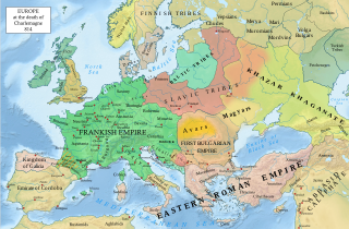
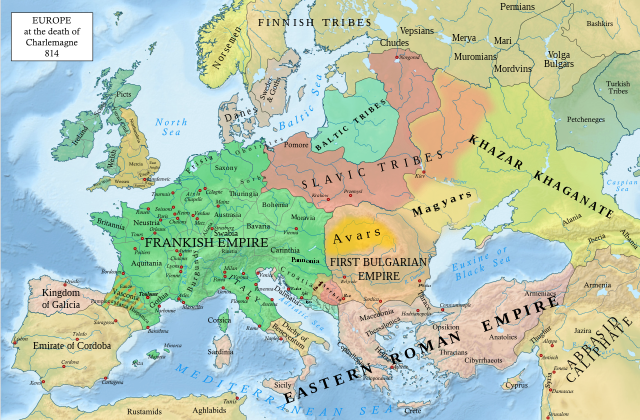
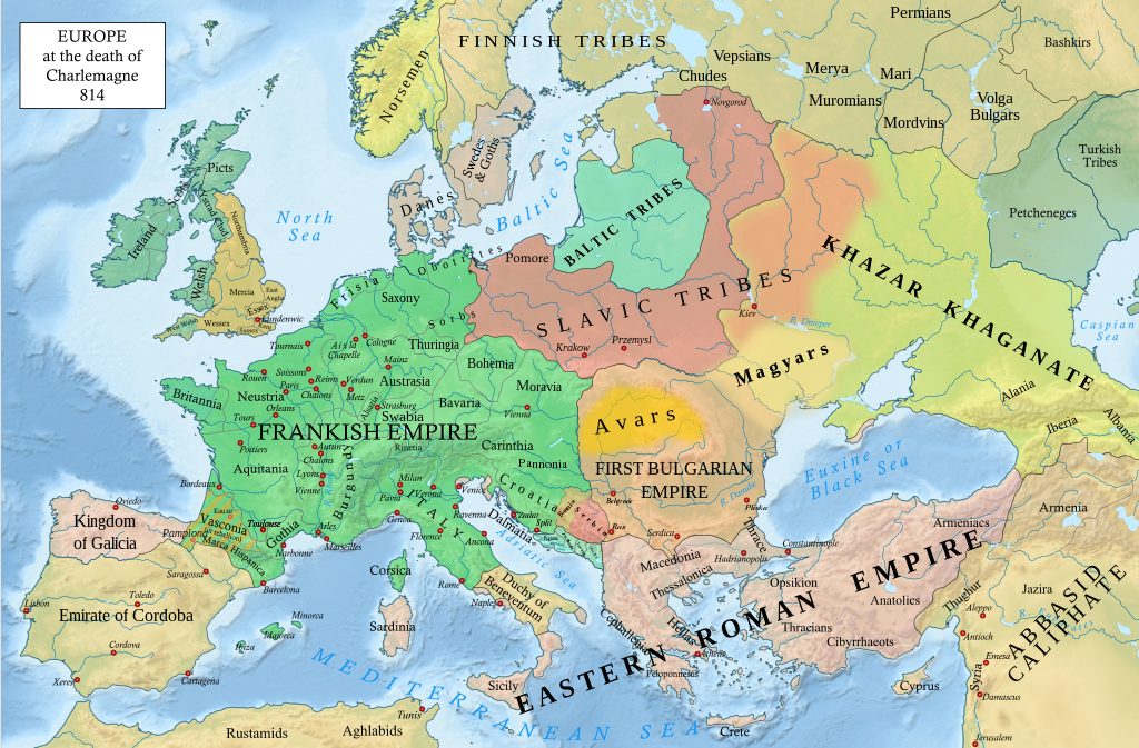
Berkas:Europe 814.svg

Ukuran asli (Berkas SVG, secara nominal 1.399 × 919 piksel, besar berkas: 3,4 MB)
Ringkasan
| Deskripsi |
English: An svg version of File:Europe 814.jpg with corrections.
List of corrections:
|
| Tanggal | |
| Sumber | "The Public Schools Historical Atlas" by Charles Colbeck. Longmans, Green; New York; London; Bombay. 1905. |
| Pembuat | Hel-hama |
| Versi lainnya |
|


_en.png)
.png)
.jpg)
Lisensi
- Anda diizinkan:
- untuk berbagi – untuk menyalin, mendistribusikan dan memindahkan karya ini
- untuk menggubah – untuk mengadaptasi karya ini
- Berdasarkan ketentuan berikut:
- atribusi – Anda harus mencantumkan atribusi yang sesuai, memberikan pranala ke lisensi, dan memberi tahu bila ada perubahan. Anda dapat melakukannya melalui cara yang Anda inginkan, namun tidak menyatakan bahwa pemberi lisensi mendukung Anda atau penggunaan Anda.
- berbagi serupa – Apabila Anda menggubah, mengubah, atau membuat turunan dari materi ini, Anda harus menyebarluaskan kontribusi Anda di bawah lisensi yang sama seperti lisensi pada materi asli.
This media file is in the public domain in the United States. This applies to U.S. works where the copyright has expired, often because its first publication occurred prior to January 1, 1929, and if not then due to lack of notice or renewal. See this page for further explanation.
|
 | |
 |
This image might not be in the public domain outside of the United States; this especially applies in the countries and areas that do not apply the rule of the shorter term for US works, such as Canada, Mainland China (not Hong Kong or Macao), Germany, Mexico, and Switzerland. The creator and year of publication are essential information and must be provided. See Wikipedia:Public domain and Wikipedia:Copyrights for more details.
|
_(St_Edwards_Crown).svg)
|
This file is licensed under the Open Government Licence version 1.0 (OGL v1.0).
|
|---|---|
|
You are free to:
See the Open Government Licence page on Meta-Wiki for more information.
|
This work is in the public domain in India because its term of copyright has expired.
The Indian Copyright Act applies in India to works first published in India. According to the Indian Copyright Act, 1957, as amended up to Act No. 27 of 2012 (Chapter V, Section 25):
|
 |
Riwayat berkas
Klik pada tanggal/waktu untuk melihat berkas ini pada saat tersebut.
| Tanggal/Waktu | Miniatur | Dimensi | Pengguna | Komentar | |
|---|---|---|---|---|---|
| terkini | 8 Januari 2023 20.05 | | 1.399 × 919 (3,4 MB) | Miki Filigranski | correction of Bosnian border, which was a separate land according to modern scholarship, contested but never completelly under Serbian or Croatian control |
| 29 November 2022 21.32 |  | 1.399 × 919 (3,39 MB) | Gyalu22 | Added Avar ethnic territory, see Bulgarians_and_Slavs_VI-VII_century.png. Also extended Magyar ethnic territory to Bessarabia | |
| 1 November 2022 10.26 |  | 1.399 × 919 (3,38 MB) | Miki Filigranski | Reverted to version as of 07:20, 31 July 2022 (UTC) | |
| 3 Agustus 2022 04.47 |  | 1.399 × 919 (3,38 MB) | Bernd21t | (ringkasan suntingan dihapus) | |
| 31 Juli 2022 07.20 |  | 1.399 × 919 (3,38 MB) | Miki Filigranski | Reverted to version as of 16:51, 27 March 2022 (UTC) | |
| 18 Juli 2022 05.13 |  | 1.399 × 919 (3,38 MB) | Ionelen | Reverted to version as of 19:41, 13 April 2022 (UTC) | |
| 12 Juli 2022 07.41 |  | 1.399 × 919 (3,38 MB) | Ahmet Q. | Reverted to version as of 16:51, 27 March 2022 (UTC) | |
| 13 April 2022 19.41 |  | 1.399 × 919 (3,38 MB) | Wojsław12 | Reverted to version as of 11:43, 14 January 2022 (UTC) | |
| 27 Maret 2022 16.51 |  | 1.399 × 919 (3,38 MB) | Silverije | Reverted to version as of 12:43, 1 June 2021 (UTC) | |
| 14 Januari 2022 11.43 |  | 1.399 × 919 (3,38 MB) | TómasdeAquino2 | Corrected POV issues of blocked sock of Crovata Miki Filigranski | |
| 1 Juni 2021 12.43 |  | 1.399 × 919 (3,38 MB) | Tropcho | Bulgar Empire -> First Bulgarian Empire | |
| 22 Mei 2021 09.32 |  | 1.399 × 919 (3,38 MB) | +JMJ+ | Fixed typo; Norsmen -> Norsemen | |
| 16 Mei 2021 15.03 |  | 1.399 × 919 (3,38 MB) | E-960 | Clean up | |
| 16 Mei 2021 12.13 |  | 1.399 × 919 (3,42 MB) | E-960 | Changed color scheme a bit, to avoid monochrome green on everything, also kept most of Itzhak Rosenberg's edits ,however middle-Vistula was inhabitted by the Slavic Masovians as noted on East Slavic tribes peoples 8th 9th century.jpg map and http://partizanai.org/karys-1962m-3-4/5269-baltu-zemes-falsifikatas | |
| 15 Mei 2021 18.40 |  | 1.399 × 919 (3,51 MB) | +JMJ+ | Veps -> Vepsians, Murom -> Muromians | |
| 15 Mei 2021 18.35 |  | 1.399 × 919 (3,52 MB) | +JMJ+ | Adjustments following 'File:Muromian-map.png' | |
| 15 Mei 2021 18.01 |  | 1.399 × 919 (3,54 MB) | +JMJ+ | Updated Eastern Carolingian Empire borders following File:Droysens-21a.jpg as recommened by E-960 and adjusted the borders of the First Bulgarian Empire following File:First Bulgarian Empire IX-X c.png | |
| 15 Mei 2021 17.31 |  | 1.399 × 919 (3,54 MB) | +JMJ+ | Reverted to version as of 21:22, 11 May 2021 (UTC) The borders for the Baltic tribes are not shown in the maps of the referenced article, but the actual text of the article. In addition, all the demands of others with regards to cleaning up the typos were also forgotten in the changes of E-960, so I must revert it to my map. | |
| 14 Mei 2021 16.22 |  | 1.399 × 919 (3,55 MB) | E-960 | Minor clean up | |
| 14 Mei 2021 15.29 |  | 1.399 × 919 (3,54 MB) | E-960 | Updated the Carolingian Empire borders based on File:Droysens-21a.jpg map | |
| 14 Mei 2021 10.34 |  | 1.399 × 919 (3,55 MB) | E-960 | Reverted to version as of 09:59, 14 May 2021 (UTC) Boundary between Slavs and Balts further up north, per original source. | |
| 14 Mei 2021 10.12 |  | 1.399 × 919 (3,54 MB) | E-960 | Reverted to version as of 21:22, 11 May 2021 (UTC) Fix | |
| 14 Mei 2021 09.59 |  | 1.399 × 919 (3,55 MB) | E-960 | Reverted to version as of 14:13, 29 December 2020 (UTC) Reverted back to the original Baltic Tribes outline, even the source cited does not show their extent as far south as middle-Vistula. | |
| 11 Mei 2021 21.22 |  | 1.399 × 919 (3,54 MB) | +JMJ+ | Adjusted Mordvinian borders following the 'File:Muromian-map.png' | |
| 11 Mei 2021 20.58 |  | 1.399 × 919 (3,55 MB) | +JMJ+ | Minor adjustments with typos - changed it to Aix la Chapelle and Thracians, among others. | |
| 11 Mei 2021 20.48 |  | 1.399 × 919 (3,55 MB) | +JMJ+ | Corrected the borders of the Baltic tribes, which was absolutely false prior to my edit. I changed them according to http://partizanai.org/karys-1962m-3-4/5269-baltu-zemes-falsifikatas, but I might need to find a better source regarding them as the source I used was about the 13th century. In addition, I added the corrections wanted by Michael!. More updates might follow soon, the eastern borders of Khazar Khaganate, Bashkirs, Mordvins, might warrant further redrawing, plus the aforementioned... | |
| 29 Desember 2020 14.13 |  | 1.399 × 919 (3,55 MB) | Miki Filigranski | Serbian-Bulgarian border and location of Ras | |
| 29 Desember 2020 13.15 |  | 1.399 × 919 (3,55 MB) | Miki Filigranski | Added the Bulgarian capital city of Pliska and slightly moved the name of Danube Bulgar Khanate. | |
| 29 Desember 2020 11.01 |  | 1.399 × 919 (3,55 MB) | Miki Filigranski | The border between Serbia and the First Bulgarian Empire and added cities of Ras and Belgrade (also known as Singidunum and Beligrad). | |
| 26 Desember 2020 19.39 |  | 1.399 × 919 (3,55 MB) | Miki Filigranski | Different color for Pagania, Zachlumia, Travunia, Dioclea. | |
| 19 September 2020 04.47 |  | 1.399 × 919 (3,54 MB) | Miki Filigranski | The border between Croatia and Serbia, the border between Serbia and Bulgarian & Byzantine Empire, the inclusion of principalities & marches of Pannonia, Pagania, Zachlumia, Travunia, Dioclea, and Thuringia, the region of Bosnia, and cities Zadar and Split in the Theme of Dalmatia, removal of Poles and Czech tribes because are not mentioned in the historical sources for the time period or didn't live in the location, and better location for Carinthia. | |
| 11 Mei 2020 18.07 |  | 1.399 × 919 (3,69 MB) | Caliniuc | Corrected name of the pagan Turko-Bulgar state on the Lower Danube | |
| 20 Oktober 2019 19.56 |  | 1.399 × 919 (10,17 MB) | One2 | Changed status of Galicia | |
| 21 Juni 2016 14.00 |  | 1.399 × 919 (10,18 MB) | Alphathon | Reverted to last working version (12:24, 8 July 2015 (UTC)) | |
| 2 Juni 2016 15.01 |  | 1.399 × 919 (10,16 MB) | Dominikmatus | fixed corrupted code | |
| 20 Maret 2016 09.11 |  | 1.399 × 919 (10,18 MB) | Ercwlff | Reverted to version as of 12:24, 8 July 2015 (UTC) | |
| 19 Maret 2016 19.24 |  | 1.399 × 919 (10,18 MB) | Ercwlff | edited mainly according to this | |
| 8 Juli 2015 15.07 |  | 1.399 × 919 (10,2 MB) | Tropcho | attempt to fix font | |
| 8 Juli 2015 12.24 |  | 1.399 × 919 (10,18 MB) | Tropcho | Removed the en:Avar Khaganate + adjustments to borders in the Balkans. Due to incomplete information, further adjustments may be necessary in the region of the Avar Khaganate and the borders between the First Bulgarian Empire, the Byzantine Empire... | |
| 13 Juni 2015 13.28 |  | 1.399 × 919 (10,22 MB) | Zorion | Lengthen multiple lines in Vasconia | |
| 8 Juni 2015 21.19 |  | 1.399 × 919 (10,22 MB) | Cplakidas | fixing Peloponnese, by 814 it was firmly in Byzantine hands in its entirety again; marking Cyprus as Byzantine-Abbasid condominium; fixing spelling of Beneventum | |
| 7 Juni 2015 23.20 |  | 1.399 × 919 (10,2 MB) | Alphathon | Changed status of Vasconia, Adriatic islands and Dalmatia per talk | |
| 31 Mei 2015 17.06 |  | 1.399 × 919 (10,16 MB) | Alphathon | Hybrid version incorporating changes post 03:40, 24 May 2015 but with Vasconia still independent | |
| 27 Mei 2015 01.11 |  | 1.399 × 919 (10,05 MB) | Zorion | Reverted to version as of 03:40, 24 May 2015 | |
| 24 Mei 2015 18.49 |  | 1.399 × 919 (10,18 MB) | Alphathon | Minor correction to Wales (Buellt was part of Seisyllwg by that point) | |
| 24 Mei 2015 17.16 |  | 1.399 × 919 (10,18 MB) | Alphathon | Added further Slavic area to Khazar Khaganate (per source map), re-integrated Vasconia into Francia (per source map; as far as I can tell it was still nominally part of Francia), enlarged Frankish Empire label, refined and corrected various subdivision... | |
| 24 Mei 2015 03.40 |  | 1.399 × 919 (10,05 MB) | Alphathon | Fixed Vasconia font and object ordering. Added Czechi blur. Added Aquitania border. | |
| 24 Mei 2015 03.14 |  | 1.399 × 919 (10,04 MB) | Alphathon | Various minor fixes and corrections, particularly Crimea. Also added blur to tribal areas | |
| 24 Mei 2015 01.02 |  | 1.399 × 919 (10,03 MB) | Alphathon | Corrected more inconsistencies with source map, particularly concerning the Eastern Roman/Byzantine Empire | |
| 24 Mei 2015 00.47 |  | 1.399 × 919 (10,03 MB) | Alphathon | Various corrections and style tweaks: • Moved word "Scots" to appropriate position between Argyll and Northern Ireland. Changed colour of Goidelic peoples to differentiate them from Brythonic peoples (as is the case on the source map); Ystrad Clud/St... | |
| 29 Juli 2014 11.25 |  | 1.399 × 919 (10,04 MB) | Zorion | Vasconia was independant from frankish kingdom until 824 | |
| 28 Januari 2013 14.56 |  | 1.399 × 919 (9,98 MB) | Cplakidas | forgot to vectorize a few names | |
| 28 Januari 2013 14.49 |  | 1.399 × 919 (9,92 MB) | Cplakidas | various tweaks and corrections, mostly re Byzantium | |
| 4 Januari 2013 11.56 |  | 1.399 × 919 (10,07 MB) | Hel-hama | colour amended to reflect original map | |
| 2 Januari 2013 09.02 |  | 1.399 × 919 (10,07 MB) | Hel-hama | text corrected | |
| 2 Januari 2013 08.09 |  | 1.399 × 919 (10,05 MB) | Hel-hama | User created page with UploadWizard |
Penggunaan berkas
Halaman berikut menggunakan berkas ini:
Penggunaan berkas global
Wiki lain berikut menggunakan berkas ini:
- Penggunaan pada af.wiki-indonesia.club
- Penggunaan pada ar.wiki-indonesia.club
- Penggunaan pada arz.wiki-indonesia.club
- Penggunaan pada bg.wiki-indonesia.club
- Penggunaan pada bn.wiki-indonesia.club
- Penggunaan pada ca.wiki-indonesia.club
- Penggunaan pada cs.wiki-indonesia.club
- Penggunaan pada cy.wiki-indonesia.club
- Penggunaan pada de.wiki-indonesia.club
- Penggunaan pada el.wiki-indonesia.club
- Penggunaan pada en.wiki-indonesia.club
- Charlemagne
- History of Europe
- Vikings
- 814
- History of Estonia
- Bulgars
- Principality of Serbia (early medieval)
- Saare County
- Early Middle Ages
- Kvenland
- Askold and Dir
- Duchy of Benevento
- Portal:Estonia
- Franks
- Višeslav of Serbia
- History of Christian thought on persecution and tolerance
- Borna (duke)
- Vlastimir
- Arab–Khazar wars
- Duchy of Gascony
- Muslim conquest of Sicily
- Prosigoj
- Rus' people
- Early Slavs
- Radoslav of Serbia
- Barbarian kingdoms
- Agriculture in the Middle Ages
- Gersuinda
- User:Falcaorib
- Penggunaan pada en.wikibooks.org
Lihat lebih banyak penggunaan global dari berkas ini.