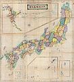
Berkas:1875 Meiji 8 Japanese Wall Map of Japan - Geographicus - Japan-meiji8-1875.jpg

Ukuran asli (6.000 × 6.601 piksel, ukuran berkas: 7,35 MB, tipe MIME: image/jpeg)

Berkas ini berasal dari Wikimedia Commons dan mungkin digunakan oleh proyek-proyek lain. Deskripsi dari halaman deskripsinya ditunjukkan di bawah ini.

Dai Nihon Chiri Zenzu
Seniman/Pembuat
Judul
Dai Nihon Chiri Zenzu
Deskripsi
English: This is a monumental Japanese map of Japan prepared in 1875 or Meiji 8. Covers the entirety of Japan inclusive of Hokkaido and the Ryukyu Islands. Cartographically this map, like most 18th century maps of Japan, harkens to the Ino Tadataka surveys of the 18th century, though this example does exhibit considerable revision. Even so, the influence of the Meiji Ishin or Meiji Restoration is evident in the form of the prefecture structure adopted in 1871. Stylistically, this map strays significantly from Edo period cartography prepared under the Tokugawa Shogunate, and, though issued early in the Meiji period, exhibits considerable western, particularly British, cartographic influence. One curious aspect of this map is that it appears unfinished. Various empty cartouches appear throughout the map but are empty and no specific area is textually identified. This unusual omission may stem from a politic decision to discontinue the map in anticipation of further revisions, or simply suggest that the completion of the map was interrupted for other, unknowable, reasons.
Tanggal 1875 (dated)
Ukuran tinggi: 59 in (149,8 cm); lebar: 53 in (134,6 cm)
dimensions QS:P2048,59U218593
dimensions QS:P2049,53U218593
Kode inventaris
Geographicus link: Japan-meiji8-1875
Sumber/Fotografer
Izin
(Menggunakan kembali berkas ini)
Ini adalah suatu perbanyakan fotografis dari sebuah karya seni dua dimensi. Karya seni tersebut berada pada domain publik karena alasan berikut:
Public domain

This work is in the public domain in its country of origin and other countries and areas where the copyright term is the author's life plus 70 years or fewer.


You must also include a United States public domain tag to indicate why this work is in the public domain in the United States.
Berkas ini telah diidentifikasi bebas dari pembatasan menurut hukum hak cipta termasuk semua hak terkait dan relevan.
Posisi resmi Wikimedia Foundation adalah bahwa "faithful reproductions of two-dimensional public domain works of art are public domain, and that claims to the contrary represent an assault on the very concept of a public domain". Untuk detilnya, lihat Commons:When to use the PD-Art tag.
Oleh karena itu, perbanyakan fotografis ini juga dianggap berada pada domain publik. Mohon diperhatikan bahwa hukum lokal mungkin saja melarang atau membatasi penggunaan kembali berkas ini di wilayah hukum anda. Lihat Commons:Reuse of PD-Art photographs.
{{PD-Art}} template without license parameter: please specify why the underlying work is public domain in both the source country and the United States
(Usage: {{PD-Art|1=|deathyear=''year of author's death''|country=''source country''}}, where parameter 1= can be PD-old-auto, PD-old-auto-expired, PD-old-auto-1996, PD-old-100 or similar. See Commons:Multi-license copyright tags for more information.)

Captions

Add a one-line explanation of what this file represents

Items portrayed in this file

menggambarkan

image/jpeg

checksum Inggris

4eac2ffb6ab572a3bbe5ff8d7277dcfb9b75d7bc

7.711.809 Bita

6.601 piksel

6.000 piksel

Riwayat berkas

Klik pada tanggal/waktu untuk melihat berkas ini pada saat tersebut.

Tanggal/WaktuMiniaturDimensiPenggunaKomentar
terkini25 Maret 2011 03.38Miniatur versi sejak 25 Maret 2011 03.386.000 × 6.601 (7,35 MB)BotMultichillT{{subst:User:Multichill/Geographicus |link=http://www.geographicus.com/P/AntiqueMap/Japan-meiji8-1875 |product_name=1875 Meiji 8 Japanese Wall Map of Japan |map_title=Dai Nihon Chiri Zenzu |description=This is a monumental Japanese map of Japan prepared i

Halaman berikut menggunakan berkas ini:

Penggunaan berkas global

Wiki lain berikut menggunakan berkas ini: