Berkas:Austrian Netherlands 1789.svg

Ukuran pratayang PNG ini dari berkas SVG ini: 450 × 456 piksel Resolusi lainnya: 237 × 240 piksel | 474 × 480 piksel | 758 × 768 piksel | 1.011 × 1.024 piksel | 2.021 × 2.048 piksel.
Ukuran asli (Berkas SVG, secara nominal 450 × 456 piksel, besar berkas: 858 KB)
Ringkasan


.svg)
.svg)
.svg)
.svg)
.svg)


.svg)
.svg)
.svg)


.png)
.png)


.svg)


.svg)

.svg)


.svg)
.svg)
.svg)
.svg)


.svg)
.png)


.svg)


.svg)
.svg)


.svg)


.svg)


.svg)
.svg)
.svg)
.svg)
.svg)
.svg)
.svg)
_cropped.svg)
.svg)
.svg)
.svg)
.svg)
.svg)
.svg)
.svg)
.svg)
.svg)
.svg)
.svg)
.svg)
.svg)
.svg)
.svg)
.svg)
.svg)
.svg)
.svg)
.svg)
.svg)
.svg)
.svg)
.svg)
.svg)
.svg)
.svg)
.svg)
.svg)
.svg)
.svg)
.svg)
.svg)
.svg)
.svg)
.svg)
.svg)
.svg)
.svg)
.svg)
.svg)
.svg)
.svg)
.svg)
.svg)
Lisensi
Saya, pemilik hak cipta dari karya ini, dengan ini menerbitkan berkas ini di bawah ketentuan berikut:
Berkas on ipartandoan sian on Creative Commons Attribution-Share Alike 3.0 Unported partadoan.
- Anda diizinkan:
- untuk berbagi – untuk menyalin, mendistribusikan dan memindahkan karya ini
- untuk menggubah – untuk mengadaptasi karya ini
- Berdasarkan ketentuan berikut:
- atribusi – Anda harus mencantumkan atribusi yang sesuai, memberikan pranala ke lisensi, dan memberi tahu bila ada perubahan. Anda dapat melakukannya melalui cara yang Anda inginkan, namun tidak menyatakan bahwa pemberi lisensi mendukung Anda atau penggunaan Anda.
- berbagi serupa – Apabila Anda menggubah, mengubah, atau membuat turunan dari materi ini, Anda harus menyebarluaskan kontribusi Anda di bawah lisensi yang sama seperti lisensi pada materi asli.
Log pengunggahan asli
This image is a derivative work of the following images:
- File:Europe_1789.svg licensed with Cc-by-sa-3.0
- 2013-04-14T03:44:26Z Alphathon 450x456 (858577 Bytes) Corrected some errors in northern Italy
- 2013-04-14T01:38:01Z Alphathon 450x456 (853881 Bytes) tweaked again
- 2013-04-14T01:36:10Z Alphathon 450x456 (853881 Bytes) Tweaked Holy Roman Empire border style
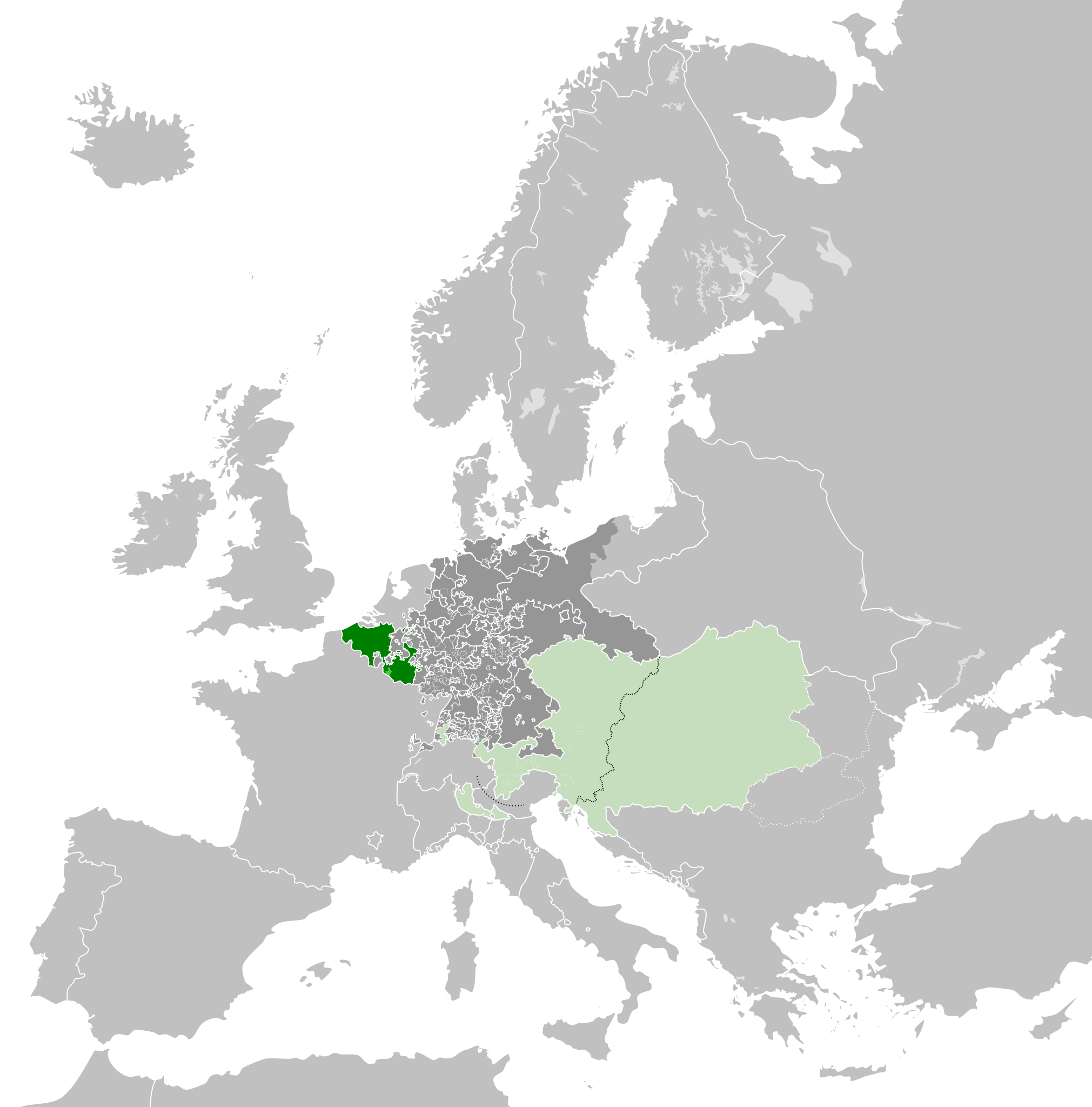
- 2013-04-14T01:33:26Z Alphathon 450x456 (853857 Bytes) == {{int:filedesc}} == {{Information |Description={{en|A blank Map of Europe circa 1789. This map also includes a border for the [[:en:Holy Roman Empire|Holy Roman Empire]]. Since there are so many small German states, they h
Uploaded with derivativeFX
Riwayat berkas
Klik pada tanggal/waktu untuk melihat berkas ini pada saat tersebut.
| Tanggal/Waktu | Miniatur | Dimensi | Pengguna | Komentar | |
|---|---|---|---|---|---|
| terkini | 17 Oktober 2021 07.38 | | 450 × 456 (858 KB) | Fenn-O-maniC | Wrong file |
| 17 Oktober 2021 07.38 |  | 450 × 456 (800 KB) | Fenn-O-maniC | Fixed the Russo-Swedish border to match the Treaty of Åbo of 1743 | |
| 17 Oktober 2021 07.36 |  | 450 × 456 (858 KB) | Fenn-O-maniC | Fixed the Russo-Swedish border to match the Treaty of Åbo of 1743 | |
| 18 April 2013 20.34 |  | 450 × 456 (878 KB) | Alphathon | Style change | |
| 18 April 2013 18.34 |  | 450 × 456 (857 KB) | Alphathon | Various fixes | |
| 15 April 2013 20.31 |  | 450 × 456 (854 KB) | Alphathon | Corrected Scandinavian borders | |
| 14 April 2013 23.18 |  | 450 × 456 (839 KB) | Alphathon | Changed colour of the remainder of the Habsburg Monarchy | |
| 14 April 2013 13.29 |  | 450 × 456 (839 KB) | Alphathon | == {{int:filedesc}} == {{Information |Description={{en|A map of the Austrian Netherlands within the Habsburg Monarchy, the Holy Roman Empire and Europe circa 1789.}}{{de|Eine Landkarte die [[:de:Öste... |
Penggunaan berkas
Halaman berikut menggunakan berkas ini:
Penggunaan berkas global
Wiki lain berikut menggunakan berkas ini:
- Penggunaan pada ar.wiki-indonesia.club
- Penggunaan pada ast.wiki-indonesia.club
- Penggunaan pada bg.wiki-indonesia.club
- Penggunaan pada cs.wiki-indonesia.club
- Penggunaan pada en.wiki-indonesia.club
- Penggunaan pada eo.wiki-indonesia.club
- Penggunaan pada et.wiki-indonesia.club
- Penggunaan pada eu.wiki-indonesia.club
- Penggunaan pada fa.wiki-indonesia.club
- Penggunaan pada fi.wiki-indonesia.club
- Penggunaan pada fr.wiki-indonesia.club
- Penggunaan pada gl.wiki-indonesia.club
- Penggunaan pada he.wiki-indonesia.club
- Penggunaan pada is.wiki-indonesia.club
- Penggunaan pada it.wiki-indonesia.club
- Penggunaan pada ja.wiki-indonesia.club
- Penggunaan pada ko.wiki-indonesia.club
- Penggunaan pada lv.wiki-indonesia.club
- Penggunaan pada mk.wiki-indonesia.club
- Penggunaan pada pt.wiki-indonesia.club
- Penggunaan pada th.wiki-indonesia.club
- Penggunaan pada tr.wiki-indonesia.club
- Penggunaan pada uk.wiki-indonesia.club
- Penggunaan pada vi.wiki-indonesia.club
- Penggunaan pada www.wikidata.org
- Penggunaan pada zh.wiki-indonesia.club