Berkas:Bermuda wv.jpg
Tak tersedia resolusi yang lebih tinggi.
Bermuda_wv.jpg (800 × 600 piksel, ukuran berkas: 335 KB, tipe MIME: image/jpeg)
Ringkasan
| Deskripsi |
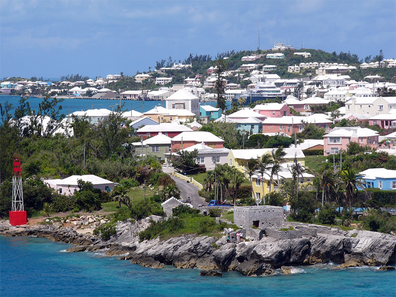
English: Residential suburb near the old St. George's Garrison, with "Town Cut Battery" or "Gate's Fort" in the foreground (with Cut Road behind it), on the northern side of the Town Cut shipping channel, and St. George's Town and harbour in the background, with Fort George on the peak of Mount Hill beyond, and a small ship is visible docked at Ordnance Island, off the town square]].
The Town Cut had been a minor channel, suitable only for small vessels to enter or exit the harbour, until dredged before the First World War. Before then, larger vessels had used the St. George's Channel between Paget Island and Governor's Island, which was watched over by Fort Paget (on Paget Island) and Smith's Fort (on Governor's Island). In the 19th Century, Fort Cunningham was erected on Paget Island, making all three of the earlier batteries redundant. Alexandra Battery (at Building Bay on St. George's Island, immediately to the north of Cut Battery) and St. David's Battery on St. David's Island were later added (there were also three other forts armed with coastal artillery batteries to the North-West of Building Bay: Fort St. Catherine's at St. Catherine's Point, and Fort Victoria and Fort Albert on Retreat Hill, to its rear). St. George's Town and the various forts and related military installations at the East End of Bermuda are together a United Nations Educational, Scientific and Cultural Organization's (UNESCO) World Heritage Site, the Historic Town of St George and Related Fortifications, Bermuda.[1][2] |
| Tanggal | 24 Agustus 2006 (original upload date) |
| Sumber | Karya sendiri |
| Pembuat | (WT-en) Legrospaumé di Wikiwisata bahasa Inggris |
| Lokasi kamera | | Lihat gambar ini dan gambar di sekitarnya di: OpenStreetMap |
|---|
References
- ↑ Bermuda Forts 1612–1957, Dr. Edward C. Harris, The Bermuda Maritime Museum Press, The Bermuda Maritime Museum, P.O. Box MA 133, Mangrove Bay, Bermuda MA BX, ISBN 0-921560-11-7
- ↑ UNESCO World Heritage Centre: Historic Town of St George and Related Fortifications, Bermuda
Lisensi
| Karya ini dilepaskan ke domain umum oleh pemiliknya, (WT-en) Legrospaumé di Wikiwisata bahasa Inggris. Lisensi ini berlaku di seluruh dunia. Di sejumlah negara, tindakan ini tidak memungkinkan secara sah; bila seperti itu: (WT-en) Legrospaumé di Wikiwisata bahasa Inggris memberikan siapa pun hak untuk menggunakan karya ini untuk tujuan apa pun, tanpa persyaratan apa pun, kecuali yang ditetapkan oleh hukum.
|
Log pengunggahan asli
| This file was imported from Wikivoyage en. |
Halaman deskripsi aslinya ada di sini. Semua nama pengguna berikut merujuk pada en.wikivoyage-old.
- 2006-08-24 12:07 (WT-en) Legrospaumé 800×600 (343391 bytes) Bermuda (Import from wikitravel.org/en)
Riwayat berkas
Klik pada tanggal/waktu untuk melihat berkas ini pada saat tersebut.
| Tanggal/Waktu | Miniatur | Dimensi | Pengguna | Komentar | |
|---|---|---|---|---|---|
| terkini | 8 Januari 2013 19.09 | | 800 × 600 (335 KB) | MGA73bot2 | {{BotMoveToCommons|en.oldwikivoyage|year={{subst:CURRENTYEAR}}|month={{subst:CURRENTMONTHNAME}}|day={{subst:CURRENTDAY}}}} == {{int:filedesc}} == {{Information |description=Bermuda |date={{Date|2006|8|24}} (original upload date) |source={{Own}}<BR />{{... |
Penggunaan berkas
Halaman berikut menggunakan berkas ini:
Penggunaan berkas global
Wiki lain berikut menggunakan berkas ini:
- Penggunaan pada el.wiki-indonesia.club
- Penggunaan pada en.wiki-indonesia.club
- Penggunaan pada en.wikivoyage.org
- Penggunaan pada es.wikivoyage.org
- Penggunaan pada fi.wiki-indonesia.club
- Penggunaan pada gl.wiki-indonesia.club
- Penggunaan pada ja.wiki-indonesia.club
- Penggunaan pada mt.wiki-indonesia.club
- Penggunaan pada nl.wiki-indonesia.club
- Penggunaan pada pt.wiki-indonesia.club
- Penggunaan pada simple.wiki-indonesia.club
- Penggunaan pada vi.wiki-indonesia.club
- Penggunaan pada vi.wikivoyage.org