Berkas:Home Insurance Building.JPG

Ukuran pratayang ini: 450 × 600 piksel. Resolusi lainnya: 180 × 240 piksel | 360 × 480 piksel | 660 × 880 piksel.
Ukuran asli (660 × 880 piksel, ukuran berkas: 525 KB, tipe MIME: image/jpeg)
| Deskripsi |
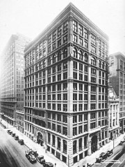
English: Exterior of the Home Insurance Building by architect William Le Baron Jenney in Chicago, Illinois. |
||||||
| Tanggal | after 1884 | ||||||
| Sumber |
|
||||||
| Pembuat | Chicago Architectural Photographing Company | ||||||
| Izin (Menggunakan kembali berkas ini) |
|


| Lokasi kamera | | Lihat gambar ini dan gambar di sekitarnya di: OpenStreetMap |
|---|
Riwayat berkas
Klik pada tanggal/waktu untuk melihat berkas ini pada saat tersebut.
| Tanggal/Waktu | Miniatur | Dimensi | Pengguna | Komentar | |
|---|---|---|---|---|---|
| terkini | 7 Juli 2018 18.41 | | 660 × 880 (525 KB) | Carl Ha | Crop should be uploaded as a new file |
| 2 Oktober 2013 03.47 |  | 573 × 880 (530 KB) | Beyond My Ken | crop to subject | |
| 3 Agustus 2012 19.35 |  | 660 × 880 (525 KB) | Cropbot | upload cropped version, operated by User:LX. Summary: lossless crop | |
| 3 Agustus 2012 19.30 |  | 687 × 1.024 (594 KB) | LX | Updating with a version that is actually better and not just upsampled | |
| 16 Februari 2011 08.39 |  | 291 × 443 (62 KB) | Beyond My Ken | Same image, better version | |
| 16 Agustus 2005 01.06 |  | 176 × 263 (20 KB) | TERdON~commonswiki | CREDIT: Jenney, William Le Baron, architect. "Home Insurance Building, Exterior, Chicago, Illinois." Building/structure/site dates: 1884. American Landscape and Architectural Design, 1850-1920, Library of Congress. The Library of Congress and the France |
Penggunaan berkas
2 halaman berikut menggunakan berkas ini:
Penggunaan berkas global
Wiki lain berikut menggunakan berkas ini:
- Penggunaan pada af.wiki-indonesia.club
- Penggunaan pada ar.wiki-indonesia.club
- Penggunaan pada ast.wiki-indonesia.club
- Penggunaan pada az.wiki-indonesia.club
- Penggunaan pada ba.wiki-indonesia.club
- Penggunaan pada bg.wiki-indonesia.club
- Penggunaan pada ca.wiki-indonesia.club
- Penggunaan pada cs.wiki-indonesia.club
- Penggunaan pada cv.wiki-indonesia.club
- Penggunaan pada cy.wiki-indonesia.club
- Penggunaan pada de.wiki-indonesia.club
- Penggunaan pada el.wiki-indonesia.club
- Penggunaan pada en.wiki-indonesia.club
Lihat lebih banyak penggunaan global dari berkas ini.