Berkas:London 1300 Historical Atlas William R Shepherd (died 1934).PNG

London_1300_Historical_Atlas_William_R_Shepherd_(died_1934).PNG (700 × 536 piksel, ukuran berkas: 644 KB, tipe MIME: image/png)

Berkas ini berasal dari Wikimedia Commons dan mungkin digunakan oleh proyek-proyek lain. Deskripsi dari halaman deskripsinya ditunjukkan di bawah ini.

Berkas ini telah digantikan oleh File:Plan of London in 1300.jpg. Disarankan untuk menggunakan berkas lain tersebut. Catatan: berkas ini tidak akan dihapus, kecuali jika secara eksplisit diusulkan untuk dihapus.
new file
File:Map of London, 1300.svg merupakan versi vektor dari berkas ini. Berkas itu harus digunakan menggantikan gambar raster ini jika kualitasnya tidak rendah.

File:London 1300 Historical Atlas William R Shepherd (died 1934).PNG → File:Map of London, 1300.svg

Untuk informasi lanjutan, lihat Bantuan:SVG.

Dalam bahasa lainnya
Alemannisch  العربية  беларуская (тарашкевіца)  български  বাংলা  català  нохчийн  čeština  dansk  Deutsch  Ελληνικά  English  British English  Esperanto  español  eesti  euskara  فارسی  suomi  français  Frysk  galego  Alemannisch  עברית  hrvatski  magyar  հայերեն  Bahasa Indonesia  Ido  italiano  日本語  ქართული  한국어  lietuvių  македонски  മലയാളം  Bahasa Melayu  norsk bokmål  Plattdüütsch  Nederlands  norsk nynorsk  norsk  occitan  polski  prūsiskan  português  português do Brasil  română  русский  sicilianu  Scots  slovenčina  slovenščina  српски / srpski  svenska  தமிழ்  ไทย  Türkçe  татарча / tatarça  українська  vèneto  Tiếng Việt  中文  中文(中国大陆)  中文(简体)  中文(繁體)  中文(马来西亚)  中文(新加坡)  中文(臺灣)  中文(臺灣)  +/−
Gambar SVG baru

Source: en:Image:London 1300 Historical Atlas William R Shepherd (died 1934).PNG, 03:43, 14 May 2005 . . CalJW (Talk) . . 700x536 (659,361 bytes) (A map of London in 1300 from a historical atlas by William R Shepherd. Apart from religious foundations and two or three other complexes, the city is confined within its walls, which are well inside the present boundary of the City of London. The City)

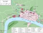
English: A map of London in 1300 from a historical atlas by William R Shepherd. Apart from religious foundations and two or three other complexes, the city is confined within its walls, which are well inside the present boundary of the City of London. The City is flanked to the east and west by the royal fortress of the Tower of London and the royal palace of Bridewell. The route from the city to the royal centre of Westminster is not yet fully built up. There is a settlement at Southwark, but it is very small.


Public domain

This work is in the public domain in its country of origin and other countries and areas where the copyright term is the author's life plus 70 years or fewer.


You must also include a United States public domain tag to indicate why this work is in the public domain in the United States.
Berkas ini telah diidentifikasi bebas dari pembatasan menurut hukum hak cipta termasuk semua hak terkait dan relevan.

Captions

Add a one-line explanation of what this file represents

Items portrayed in this file

menggambarkan

image/png

Riwayat berkas

Klik pada tanggal/waktu untuk melihat berkas ini pada saat tersebut.

Tanggal/WaktuMiniaturDimensiPenggunaKomentar
terkini20 Mei 2006 18.20Miniatur versi sejak 20 Mei 2006 18.20700 × 536 (644 KB)SiebrandHigher resolution from source
25 Oktober 2005 07.59Miniatur versi sejak 25 Oktober 2005 07.59299 × 229 (134 KB)JaT~commonswikiMap of London 1300

Tidak ada halaman yang menggunakan berkas ini.

Penggunaan berkas global

Wiki lain berikut menggunakan berkas ini:

Metadata