Berkas:Philippines.A2002088.0220.1km.jpg

Ukuran asli (1.150 × 1.500 piksel, ukuran berkas: 417 KB, tipe MIME: image/jpeg)
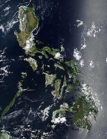
Credit: Jacques Descloitres, MODIS Land Rapid Response Team, NASA/GSFC
Red dots (or outlines in the high-resolution imagery) indicate MODIS9 detection of thermal anomalies throughout the Philippines on March 29, 2002. In most cases, the anomaly is a fire, for example, all the locations marked on the northernmost island, Luzon. However, south of center, on the southern tip of Negros, the thermal anomaly is likely volcanic activity, and the red dot left of center of the main part of Mindanao (lower right) marks the location of a volcano called Mount Ragang.
http://visibleearth.nasa.gov/view_rec.php?id=2656
| Berkas ini berada dalam domain publik di Amerika Serikat karena semata-mata diciptakan oleh NASA. Kebijakan hak cipta NASA menyatakan bahwa "materi NASA tidak dilindungi oleh hak cipta kecuali dicatat". (Lihat Template:PD-USGov, Halaman kebijakan hak cipta NASA atau JPL Image Use Policy.) | ||
 |
Peringatan:
|
Riwayat berkas
Klik pada tanggal/waktu untuk melihat berkas ini pada saat tersebut.
| Tanggal/Waktu | Miniatur | Dimensi | Pengguna | Komentar | |
|---|---|---|---|---|---|
| terkini | 25 Oktober 2005 21.55 | | 1.150 × 1.500 (417 KB) | Brian0918 | Credit: Jacques Descloitres, MODIS Land Rapid Response Team, NASA/GSFC Red dots (or outlines in the high-resolution imagery) indicate MODIS9 detection of thermal anomalies throughout the Philippines on March 29, 2002. In most cases, the anomaly is a fire |
Penggunaan berkas
Halaman berikut menggunakan berkas ini:
Penggunaan berkas global
Wiki lain berikut menggunakan berkas ini:
- Penggunaan pada af.wiki-indonesia.club
- Penggunaan pada ar.wiki-indonesia.club
- Penggunaan pada ast.wiki-indonesia.club
- Penggunaan pada de.wiki-indonesia.club
- Penggunaan pada en.wiki-indonesia.club
- Penggunaan pada es.wiki-indonesia.club
- Penggunaan pada es.wiktionary.org
- Penggunaan pada fr.wiki-indonesia.club
- Penggunaan pada hr.wiki-indonesia.club
- Penggunaan pada ilo.wiki-indonesia.club
- Penggunaan pada it.wiki-indonesia.club
- Penggunaan pada km.wiki-indonesia.club
- Penggunaan pada ko.wiki-indonesia.club
- Penggunaan pada nl.wiki-indonesia.club
- Penggunaan pada pl.wiki-indonesia.club
- Penggunaan pada pl.wikinews.org
- Penggunaan pada pt.wiki-indonesia.club
- Penggunaan pada sh.wiki-indonesia.club
- Penggunaan pada sq.wiki-indonesia.club
- Penggunaan pada tl.wiki-indonesia.club
- Penggunaan pada uk.wiki-indonesia.club