Berkas:Zanj Rebellion.svg

Ukuran pratayang PNG ini dari berkas SVG ini: 750 × 600 piksel Resolusi lainnya: 300 × 240 piksel | 600 × 480 piksel | 960 × 768 piksel | 1.280 × 1.024 piksel | 2.560 × 2.048 piksel | 900 × 720 piksel.
Ukuran asli (Berkas SVG, secara nominal 900 × 720 piksel, besar berkas: 1,2 MB)
Ringkasan
| Deskripsi |
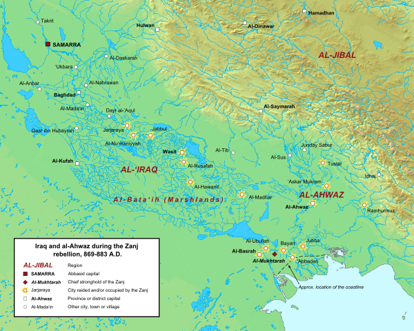
English: Map of the central Abbasid caliphate during the rebellion of the Zanj, from 869 to 883 A.D. All settlements on this map are listed by al-Tabari in his History of the Prophets and Kings, trans. "The History of al-Tabari," volumes 35 through 37. The location of cities and towns that no longer exist were determined using the maps of Le Strange and Popovic in their respective works.
Background topography taken from DEMIS Mapserver, which are public domain. Works Cited:
|
| Tanggal | |
| Sumber | Karya sendiri |
| Pembuat | Ro4444 |
Lisensi
Saya, pemilik hak cipta dari karya ini, dengan ini menerbitkan berkas ini di bawah ketentuan berikut:
Berkas on ipartandoan sian on Creative Commons Attribution-Share Alike 3.0 Unported partadoan.
- Anda diizinkan:
- untuk berbagi – untuk menyalin, mendistribusikan dan memindahkan karya ini
- untuk menggubah – untuk mengadaptasi karya ini
- Berdasarkan ketentuan berikut:
- atribusi – Anda harus mencantumkan atribusi yang sesuai, memberikan pranala ke lisensi, dan memberi tahu bila ada perubahan. Anda dapat melakukannya melalui cara yang Anda inginkan, namun tidak menyatakan bahwa pemberi lisensi mendukung Anda atau penggunaan Anda.
- berbagi serupa – Apabila Anda menggubah, mengubah, atau membuat turunan dari materi ini, Anda harus menyebarluaskan kontribusi Anda di bawah lisensi yang sama seperti lisensi pada materi asli.
Riwayat berkas
Klik pada tanggal/waktu untuk melihat berkas ini pada saat tersebut.
| Tanggal/Waktu | Miniatur | Dimensi | Pengguna | Komentar | |
|---|---|---|---|---|---|
| terkini | 16 Juni 2015 14.42 | | 900 × 720 (1,2 MB) | Ro4444 | Changing location of al-Madhar to 31° 28' 23.4726" N, 47° 23' 4.4982", the location of the burial place of 'Abdallah ibn 'Ali ibn Abi Talib. See M. Streck, "Maisan," ''E.J. Brill's First Encyclopaedia of Islam, Volume V,'' (Leiden: E.J. Brill, 1927),... |
| 3 Maret 2013 21.13 |  | 900 × 720 (1,2 MB) | Ro4444 | User created page with UploadWizard |
Penggunaan berkas
Halaman berikut menggunakan berkas ini:
Penggunaan berkas global
Wiki lain berikut menggunakan berkas ini:
- Penggunaan pada ar.wiki-indonesia.club
- Penggunaan pada arz.wiki-indonesia.club
- Penggunaan pada azb.wiki-indonesia.club
- Penggunaan pada ca.wiki-indonesia.club
- Penggunaan pada cy.wiki-indonesia.club
- Penggunaan pada de.wiki-indonesia.club
- Penggunaan pada en.wiki-indonesia.club
- Penggunaan pada es.wiki-indonesia.club
- Penggunaan pada fa.wiki-indonesia.club
- Penggunaan pada fr.wiki-indonesia.club
- Penggunaan pada ga.wiki-indonesia.club
- Penggunaan pada he.wiki-indonesia.club
- Penggunaan pada ms.wiki-indonesia.club
- Penggunaan pada pt.wiki-indonesia.club
- Penggunaan pada sv.wiki-indonesia.club
- Penggunaan pada tr.wiki-indonesia.club
- Penggunaan pada www.wikidata.org
- Penggunaan pada zh.wiki-indonesia.club