Pegunungan Catskill
Pegunungan Catskill, sebuah daerah di New York di barat laut New York City dan barat daya Albany, adalah sebuah plato terpisah asli, yaitu daerah terangkat yang mengalami erosi menjadi relief. Pegunungan Catskill adalah pegunungan yang membentang ke timur serta bentangan tertinggi dari Plato Allegheny.[1] Pegunungan ini kadang dianggap sebagai perpanjangan Pegunungan Appalachia hingga Upstate New York, padahal tidak berhubungan secara geologi. Pegunungan Catskill terletak di sebelah barat Sungai Hudson dan berada di dalam teritori enam county (Otsego, Delaware, Sullivan, Schoharie, Greene, dan Ulster). Pegunungan ini juga dianggap sebagai bentang fisiografis dari provinsi Plato Appalachia yang lebih besar, yang ternyata juga merupakan bagian dari divisi fisiografis Appalachia yang lebih besar lagi.[2] Pegunungan ini termasuk dalam wilayah ekologi Hutan Dataran Tinggi Allegheny.
| Pegunungan Catskill | |
| Range | |
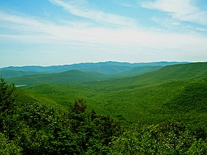
Slide Mountain dan puncak-puncak di sekitarnya dilihat dari Twin Mountain di Catskill utara.
| |
| Negara | Amerika Serikat |
|---|---|
| Provinsi | New York |
| Region | Hudson Valley |
| County | Ulster, Greene, Sullivan, Delaware, Schoharie |
| Batas | Poconos, Shawangunk Ridge |
| Komunitas | Hunter, Tannersville, Monticello, Liberty |
| Titik tertinggi | Slide Mountain |
| - elevasi | 4.154 ft (1.266 m) |
| Panjang | 111 mi (179 km), N/S |
| Lebar | 102 mi (164 km), E/W |
| Area | 15.259 km2 (5.892 sq mi) |
| Geology | Sedimenter |
| Period | Devonian, Mississippian |
Peta region utama Pegunungan Appalachia timur laut, dengan Catskill diberi tanda "C".
| |
Lihat pula
suntingCatatan kaki
sunting- ^ "REGIONAL TOPOGRAPHY". Catskills GIS Atlas. Catskill Center. Diarsipkan dari versi asli tanggal 2009-10-29. Diakses tanggal 2009-10-12.
- ^ "Physiographic divisions of the conterminous U. S." U.S. Geological Survey. Diakses tanggal 2007-12-06.
Bahan bacaan
sunting- Heilprin, Angelo (1907). "The Catskill Mountains". Bulletin of the American Geographical Society. 39 (4): 193–201. doi:10.2307/198709. ISSN 0190-5929. JSTOR 198709.
- McIntosh, Robert P. (1962). "The forest cover of the Catskill Mountain region, New York, as indicated by land survey records". American Midland Naturalist. 68 (2): 409–23. doi:10.2307/2422746. ISSN 0003-0031. JSTOR 2422746.
- McIntosh, Robert P. (1972). "Forests of the Catskill Mountains, New York". Ecological Monographs. 42 (2): 143–61. doi:10.2307/1942261. JSTOR 1942261.
- McIntosh, R. P. (1964). "The spruce-fir forests of the Catskill Mountains". Ecology. 45 (2): 314–26. doi:10.2307/1933844. ISSN 0012-9658. JSTOR 1933844.
- Rich, John Lyon (1906). "Local glaciation in the Catskill Mountains". The Journal of Geology. 14 (2): 113–21. doi:10.1086/621285. ISSN 0022-1376.
- Shepard, Paul (1957). "Paintings of the New England landscape: a scientist looks at their geomorphology". College Art Journal. 17 (1): 30–43. doi:10.2307/773655. ISSN 1543-6322. JSTOR 773655.
- Weathers, K. C. (2000). "The effect of landscape features on deposition to Hunter Mountain, Catskill Mountains, New York". Ecological Applications. 10 (2): 528–40. doi:10.1890/1051-0761(2000)010[0528:TEOLFO]2.0.CO;2. ISSN 1051-0761.
Pranala luar
sunting- Hiking Guide to Catskill High Peaks Catskill 3500 Club
- History of Catskill Mountains Sleepaway Camps
- Website for the Catskill Mountain Club hiking
- The Catskill Archive - History of the Catskill Mountains
- The Catskill Mountain Foundation
- The Catskill Center
- The Catskill Watershed Corporation
- Catskill Region Photo Gallery Diarsipkan 2015-10-19 di Wayback Machine.
- Catskill Mountainkeeper Protecting the Six Counties of the Catskills
- Catskill Mountain Businesses listed on Hudson Valley Directory

