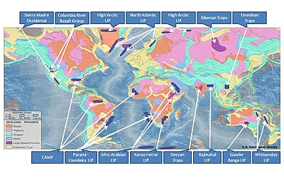
Provinsi beku besar
Provinsi beku besar (Large igneous province, LIP) adalah akumulasi batuan beku yang sangat besar, yang mencakup batuan beku intrusif (sill, korok) dan batuan beku ekstrusif (seperti aliran lava dan deposit tefra) yang naik saat magma bergerak melalui kerak ke permukaan. Formasi LIP dihubungkan dengan bulu mantel atau dengan proses-proses yang berhubungan dengan lempeng tektonik divergen.[1] Formasi beberapa provinsi-provinsi beku besar pada 500 juta tahun terakhir bertepatan waktunya dengan kepunahan massal dan perubahan iklim mendadak, yang mengarah ke beragam hipotesis mengenai hubungan kausal antaranya. LIP secara dasar berbeda dengan gunung berapi aktif atau sistem-sistem vulkanik lainnya di masa kini.

Titik panas LIP
sunting| Provinsi | Wilayah | Titik panas | Sumber |
|---|---|---|---|
| Grup Basal Sungai Columbia | AS barat laut | Titik panas Yellowstone | [2][3] |
| Basal Banjir Etiopia-Yaman | Etiopia, Yaman | [2] | |
| Provinsi Beku Atlantik Utara | Kanada utara, Greenland, Kepulauan Faroe, Norwegia, Irlandia dan Skotlandia. | Titik panas Islandia | [2] |
| Trap Deccan | India | Titik panas Réunion | [2] |
| Trap Rajmahal | India Timur | Rabung Ninety East | [4][5] |
| Dataran tinggi Kerguelen | Samudera Hindia | Titik panas Kerguelen | [4] |
| Dataran Tinggi Ontong Java | Samudera Pasifik | Titik panas Louisville | [2][6] |
| Paraná and Etendeka traps | Brazil–Namibia | Titik panas Tristan | [2] |
| Provinsi Karoo-Ferrar | Afrika Selatan, Antarktika, Australia dan Selandia Baru | Pulau Marion | [2] |
| Provinsi beku besar Karibia | Dataran tinggi laut Karibia-Kolombia | Titik panas Galápagos | [7][8] |
| Provinsi beku besar Mackenzie | Busur Kanada | Titik panas Mackenzie | [9] |
Referensi
sunting- ^ Foulger, G. R. (2010). Plates vs. Plumes: A Geological Controversy. Wiley-Blackwell. ISBN 978-1-4051-6148-0.
- ^ a b c d e f g M.A. Richards, R.A. Duncan, V.E. Courtillot; Flood Basalts and Hot-Spot Tracks: Plume Heads and Tails; SCIENCE, VOL. 246 (1989) 103–108
- ^ Nash, Barbara P.; Perkins, Michael E.; Christensen, John N.; Lee, Der-Chuen; Halliday, A.N. (2006). "The Yellowstone hotspot in space and time: Nd and Hf isotopes in silicic magmas". Earth and Planetary Science Letters. 247 (1–2): 143–156. Bibcode:2006E&PSL.247..143N. doi:10.1016/j.epsl.2006.04.030.
- ^ a b Weis, D.; et al. (1993). "The Influence of Mantle Plumes in Generation of Indian Oceanic Crust". Synthesis of Results from Scientific Drilling in the Indian Ocean. Geophysical Monograph. Geophysical Monograph Series. 70. hlm. 57–89. Bibcode:1992GMS....70...57W. doi:10.1029/gm070p0057. ISBN 9781118668030.
- ^ E.V. Verzhbitsky. "Geothermal regime and genesis of the Ninety-East and Chagos-Laccadive ridges." Journal of Geodynamics, Volume 35, Issue 3, April 2003, Pages 289–302
- ^ Antretter, M.; Riisager, P.; Hall, S.; Zhao, X.; Steinberger, B. (2004). "Modelled palaeolatitudes for the Louisville hot spot and the Ontong Java Plateau". Geological Society, London, Special Publications. 229 (1): 21–30. Bibcode:2004GSLSP.229...21A. doi:10.1144/GSL.SP.2004.229.01.03.
- ^ Sur l'âge des trapps basaltiques (On the ages of flood basalt events); Vincent E. Courtillot & Paul R. Renne; Comptes Rendus Geoscience; Vol: 335 Issue: 1, January 2003; pp: 113–140
- ^ Hoernle, Kaj; Hauff, Folkmar; van den Bogaard, Paul (2004). "70 m.y. history (139–69 Ma) for the Caribbean large igneous province". Geology. 32 (8): 697–700. Bibcode:2004Geo....32..697H. doi:10.1130/g20574.1.
- ^ Ernst, Richard E.; Buchan, Kenneth L. (2001). Mantle plumes: their identification through time. Geological Society of America. hlm. 143, 145, 146, 147, 148, 259. ISBN 978-0-8137-2352-5.