Rumson, New Jersey
Rumson adalah borough di County Monmouth, di negara bagian New Jersey, AS, dan merupakan bagian dari New York Metropolitan Area. Menurut sensus Amerika Serikat 2020, populasi borough berjumlah 7,343,[9][10] kenaikan sebanyak 221 (+3.1%) dari sensus 2010 yang berjumlah 7,122,[19][20] yang pada gilirannya merupakan penurunan sebanyak 15 (−0.2%) dari 7,137 pada tahun 2000.[21]
Rumson, New Jersey | |
|---|---|
 Lauriston | |
 Peta Rumson di County Monmouth. Selipan: Lokasi County Monmouth ditandai di Negara Bagian New Jersey. | |
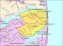
 Peta Rumson, New Jersey oleh Biro Sensus | |
| Koordinat: 40°21′43″N 74°00′14″W / 40.362°N 74.004°W[1][2] | |
| Negara | |
| Negara bagian | |
| County | Monmouth |
| Inkorporasi | 18 Juni 1907 |
| Pemerintahan | |
| • Jenis | Borough |
| • Badan | Dewan Borough |
| • Wali kota | Joseph K. Hemphill (R, jabatan berakhir 31 Desember 2023)[3][4] |
| • Administrator / Petugas kota | Thomas S. Rogers[5] |
| Luas | |
| • Total | 7,11 sq mi (18,42 km2) |
| • Luas daratan | 5,07 sq mi (13,12 km2) |
| • Luas perairan | 2,04 sq mi (5,30 km2) 28.76% |
| Peringkat | ke-242 dari 565 di negara bagian ke-16 dari 53 di county[1] |
| Ketinggian | 36 ft (11 m) |
| Populasi | |
| • Total | 7.343 |
| • Perkiraan | 7.230 |
| • Peringkat | ke-309 dari 565 di negara bagian ke-23 dari 53 di county[12] |
| • Kepadatan | 1.449,2/sq mi (5,595/km2) |
| • Peringkat kepadatan | ke-340 dari 565 di negara bagian ke-41 dari 53 di county[12] |
| Zona waktu | UTC−05:00 (Timur (EST)) |
| • Musim panas (DST) | UTC−04:00 (Timur (EDT)) |
| Kode ZIP | |
| Kode area telepon | 732[15] |
| Kode FIPS | 3402565130[1][16][17] |
| ID fitur GNIS | 0885381[1][18] |
| Situs web | www |
Rumson dibentuk oleh undang-undang Badan Legislatif New Jersey pada 15 Maret 1907, dari sebagian Township Shrewsbury, berdasarkan hasil referendum yang diadakan tanggal 18 Juni 1907.[22][23]
Borough ini merupakan salah satu komunitas berpendapatan tertinggi di negara bagian tersebut.[24] Dalam American Community Survey 2013–2017, Rumson memiliki pendapatan rumah tangga rata-rata sebanyak $158,229 (peringkat ke-24 di negara bagian) dan termasuk 43.9% pendapatan rumah tangga lebih dari $200,000 setiap tahunnya.[25]
Rumson berada di antara tagihan pajak properti tahunan tertinggi di New Jersey, dan merupakan yang tertinggi di County Monmouth, dengan $20,602 pada tahun 2018, dibandingkan dengan rata-rata negara bagian sebanyak $8,767.[26]
Pada tahun 2010, Forbes.com meletakkan Rumson di peringkat ke-192 dalam daftar "America's Most Expensive ZIP Codes", dengan harga rumah rata-rata $1,104,271.[27]
Rujukan
sunting- ^ a b c d 2019 Census Gazetteer Files: New Jersey Places, United States Census Bureau. Accessed July 1, 2020.
- ^ US Gazetteer files: 2010, 2000, and 1990, United States Census Bureau. Accessed September 4, 2014.
- ^ Kesalahan pengutipan: Tag
<ref>tidak sah; tidak ditemukan teks untuk ref bernamaMayorCouncil - ^ 2023 New Jersey Mayors Directory, New Jersey Department of Community Affairs, updated February 8, 2023. Accessed February 10, 2023.
- ^ Office of the Borough Clerk, Borough of Rumson. Accessed March 11, 2023.
- ^ Kesalahan pengutipan: Tag
<ref>tidak sah; tidak ditemukan teks untuk ref bernamaDataBook - ^ "ArcGIS REST Services Directory". United States Census Bureau. Diakses tanggal October 11, 2022.
- ^ USGS GNIS: Borough of Rumson, Geographic Names Information System. Accessed March 11, 2013.
- ^ a b c Kesalahan pengutipan: Tag
<ref>tidak sah; tidak ditemukan teks untuk ref bernamaCensus2020 - ^ a b Kesalahan pengutipan: Tag
<ref>tidak sah; tidak ditemukan teks untuk ref bernamaLWD2020 - ^ Kesalahan pengutipan: Tag
<ref>tidak sah; tidak ditemukan teks untuk ref bernamaPopEst - ^ a b Population Density by County and Municipality: New Jersey, 2020 and 2021, New Jersey Department of Labor and Workforce Development. Accessed March 1, 2023.
- ^ Look Up a ZIP Code for Rumson, NJ, United States Postal Service. Accessed July 19, 2012.
- ^ Zip Codes, State of New Jersey. Accessed August 29, 2013.
- ^ Area Code Lookup – NPA NXX for Rumson, NJ, Area-Codes.com. Accessed August 29, 2013.
- ^ U.S. Census website, United States Census Bureau. Accessed September 4, 2014.
- ^ Geographic Codes Lookup for New Jersey, Missouri Census Data Center. Accessed April 1, 2022.
- ^ US Board on Geographic Names, United States Geological Survey. Accessed September 4, 2014.
- ^ Kesalahan pengutipan: Tag
<ref>tidak sah; tidak ditemukan teks untuk ref bernamaCensus2010 - ^ Kesalahan pengutipan: Tag
<ref>tidak sah; tidak ditemukan teks untuk ref bernamaLWD2010 - ^ Table 7. Population for the Counties and Municipalities in New Jersey: 1990, 2000 and 2010, New Jersey Department of Labor and Workforce Development, February 2011. Accessed May 1, 2023.
- ^ Snyder, John P. The Story of New Jersey's Civil Boundaries: 1606–1968, Bureau of Geology and Topography; Trenton, New Jersey; 1969. p. 184. Accessed July 19, 2012.
- ^ Honeyman, Abraham Van Doren. Index-analysis of the Statutes of New Jersey, 1896–1909: Together with References to All Acts, and Parts of Acts, in the 'General Statutes' and Pamphlet Laws Expressly Repealed: and the Statutory Crimes of New Jersey During the Same Period, p. 245. New Jersey Law Journal Publishing Company, 1910. Accessed September 27, 2015.
- ^ Rumson, New Jersey, NeighborhoodScout. Accessed May 10, 2023.
- ^ Cervenka, Susanne. "Rich in New Jersey: Here are the 50 wealthiest towns in the state. Is yours one of them?", Asbury Park Press, July 1, 2019. Accessed May 10, 2023. "24. Rumson County: Monmouth County - Median household income: $158,229 Percent making more than $200,000: 43.9%"
- ^ Kesalahan pengutipan: Tag
<ref>tidak sah; tidak ditemukan teks untuk ref bernamaNJ2019 - ^ Staff. "America's Most Expensive ZIP Codes: In these neighborhoods $4 million homes are the norm.", Forbes, September 27, 2010. Accessed July 29, 2011.
Pranala luar
suntingTemplat:County Monmouth, New Jersey Templat:Daerah Jersey Shore


