Berkas:Superpower map 1945.png

Ukuran pratayang ini: 800 × 351 piksel. Resolusi lainnya: 320 × 140 piksel | 640 × 281 piksel | 1.425 × 625 piksel.
Ukuran asli (1.425 × 625 piksel, ukuran berkas: 23 KB, tipe MIME: image/png)
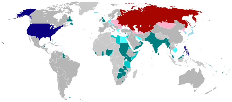
Legend
English:
English (en): Map of the world in 1945 with dependencies in lighter shading and respective superpowers at the time.
British Trust Territories
British Postwar Occupations
US postwar Occupations
Soviet postwar Occupations
বাংলা :
বাংলা (bn): ১৯৪৫ সালের মানচিত্রে পরাশক্তি ও তাদের উপর নির্ভর রাষ্ট্রসমূহ
ব্রিটিশ সাম্রাজ্য
ব্রিটিশদের বিশ্বস্ত অঞ্চলসমূহ
যুক্তরাষ্ট্র
যুক্তরাষ্ট্র বিশ্বস্ত অঞ্চলসমুহ
সোভিয়েত ইউনিয়ন
| Karya ini dilepaskan ke domain umum oleh pemiliknya, projectname di Wikipedia bahasa Inggris. Lisensi ini berlaku di seluruh dunia. Di sejumlah negara, tindakan ini tidak memungkinkan secara sah; bila seperti itu: projectname memberikan siapa pun hak untuk menggunakan karya ini untuk tujuan apa pun, tanpa persyaratan apa pun, kecuali yang ditetapkan oleh hukum. |
.
Riwayat berkas
Klik pada tanggal/waktu untuk melihat berkas ini pada saat tersebut.
| Tanggal/Waktu | Miniatur | Dimensi | Pengguna | Komentar | |
|---|---|---|---|---|---|
| terkini | 19 Oktober 2020 01.25 | | 1.425 × 625 (23 KB) | RickoTroanman22 | Fixed Hong Kong, also Tibet did not claim Inner Tibet. |
| 6 Januari 2019 22.22 |  | 1.425 × 625 (39 KB) | BMacZero | colored most Aleutian Islands as United States | |
| 2 Juli 2017 14.41 |  | 1.425 × 625 (39 KB) | Fireinacrowdedtheatre | Changed New Zealand to grey; the majority-white Dominions were not under British control by 1945 (except Newfoundland). Also added Soviet occupation of central Europe and Mongolia, British occupation of Greece, American occupation of Iceland, and the B... | |
| 7 Oktober 2014 23.11 |  | 1.425 × 625 (43 KB) | ZaidRock11 | Added post-World War II occupations in 1945 (Germany, Austria, Korea, Japan, Kwantung, Indochina); New Zealand did get full independence until 1947. | |
| 9 Juni 2013 07.41 |  | 1.425 × 625 (36 KB) | Elmor | Germany occupation zones+Saar | |
| 10 Februari 2012 00.11 |  | 1.425 × 625 (51 KB) | Quintucket | Reverted to version as of 17:28, 20 August 2011 I missed the addition of Trust territories | |
| 28 Januari 2012 07.14 |  | 1.357 × 628 (52 KB) | Quintucket | Reverted to version as of 21:44, 27 June 2007 Like User:Swarm said, India and the Philippines were still colonies at the time. Belarus and Ukraine were both UN members, which doesn't mean we should show them as non-USSR | |
| 1 Desember 2011 08.12 |  | 1.425 × 625 (57 KB) | 23prootie~commonswiki | The Philippines and India are United Nations members in 1945 with guaranteed independence. They don't count. | |
| 20 Agustus 2011 17.28 |  | 1.425 × 625 (51 KB) | Swarm | re-add Philippines, which did not gain independence until 1946. It was commonwealth status they gained in 1934, not independence. | |
| 27 Oktober 2010 00.29 |  | 1.425 × 625 (51 KB) | Vadac | Clearer version, the Philippines became independent in 1934, added Mandates and Trust Territories. |
Penggunaan berkas
2 halaman berikut menggunakan berkas ini:
Penggunaan berkas global
Wiki lain berikut menggunakan berkas ini:
- Penggunaan pada ar.wiki-indonesia.club
- Penggunaan pada ast.wiki-indonesia.club
- Penggunaan pada az.wiki-indonesia.club
- Penggunaan pada be.wiki-indonesia.club
- Penggunaan pada el.wiki-indonesia.club
- Penggunaan pada en.wiki-indonesia.club
- Penggunaan pada es.wiki-indonesia.club
- Penggunaan pada fa.wiki-indonesia.club
- Penggunaan pada fr.wiki-indonesia.club
- Penggunaan pada he.wiki-indonesia.club
- Penggunaan pada hy.wiki-indonesia.club
- Penggunaan pada ja.wiki-indonesia.club
- Penggunaan pada ko.wiki-indonesia.club
- Penggunaan pada lt.wiki-indonesia.club
- Penggunaan pada no.wiki-indonesia.club
- Penggunaan pada pl.wiki-indonesia.club
- Penggunaan pada pt.wiki-indonesia.club
- Penggunaan pada ru.wiki-indonesia.club
- Penggunaan pada sco.wiki-indonesia.club
- Penggunaan pada ta.wiki-indonesia.club
- Penggunaan pada th.wiki-indonesia.club
- Penggunaan pada uz.wiki-indonesia.club
- Penggunaan pada zh-yue.wiki-indonesia.club
- Penggunaan pada zh.wiki-indonesia.club